Wednesday 28 March 2012

Whangerei NZ

We have had a quiet day today after yesterday's long drive.  we decided to visit the last 2 places on our list here in Whangerei - the Clapham National Clock Museum and the Sub-Tropical Quarry Gardens.


The National Clock Museum is a collection of many, many timepieces collected by Archibald Clapham.  This collection has everything from a 1660 Harrison ship's chronometer, the very first type of chronometer to accurately calculate longitude, to Mickey Mouse novelty clocks.  There were cuckoo clocks, a painted Viennese clock, grandfather, grandmother and grand-daughter clocks, mantle clocks and even a clock made from Meccano.  We saw a water clock, a candle clock and an "anti-clock" that runs anti-clockwise.

After lunch we visited the Sub-Tropical Quarry Gardens.  These gardens are in a disused quarry and have a feature lake in the centre.  The gardens have all manner of sub-tropical plants from camellias to bromeliads and there are lots of walks around to admire the plants.  Being sub-tropical many of the plants have distinctive coloured foliage.

Tuesday 27 March 2012

Kia Ora

Kia Ora from Aotearoa.  Hi from The Land of the Long White Cloud.  G'day from NZ.


We had an uneventful flight from Sydney to Auckland on Saturday 24th March.  We left Sydney about 20 minutes late and landed in Auckland about 20 minutes early, thanks to a hefty tailwind.  We picked up our hire car just as it started to rain.  After a slight  directional mishap on our way out of Auckland (i.e. we got lost and were helped on our way by a very nice lady who was heading our way so we were able to follow her to the motorway), we were on our way to Northland - the spiky bit on the North Island.  We drove in the rain for 2 1/2 hours to Whangerei (pronounced fong-a-ray)  and booked into our home for the next 6 nights.  We have a very nice "tourist flat" at the Alpha Holiday Park.  We'll probably stay in tourist flats for much of our holiday in New Zealand; they are like a self catering motel with separate bedroom.


Day One, we decided to orientate ourselves and see the sights on Whangerei.  First stop was the Whangerei Falls, a 26m high waterfall.  This is a very popular picnic and walking spot and there were plenty of people about.


We walked the 30 minute loop walk to the bottom of the falls through the rainforest.  It was like walking through Middle Earth and we could imagine hobbits and elves hiding amongst the trees.  The well kept path wove past tree ferns and huge kauri trees. There was a group of people abseiling next to the falls.

After the falls we drove to the nearby AH Reed Memorial Kauri Park where we walked among the canopy of the forest to see the giant kauri.  In a race to get to the light, climbers, vines and epiphytes grow on the trunks of the trees and tree ferns.
Then it was off to the Parihaka Lookout to get some panoramic views of Whangerei.  The war memorial is also at this lookout and there is a walk to a maori pa site.  A pa was a maori village, built on several levels with each level heavily fortified.  A pa was almost impenetrable.

Monday 26th March we decided to drive to the Bay of Islands, about 75km north of Whangerei.  Driving in New Zealand is slower than we are used to in Australia.  Even though the speed limit is 100kph, we seem to average about 60kph unless we are on a motorway.  The roads are generally narrow and winding. We took the "scenic route" rather than the direct route north.  We were able to get views of the islands along the way.  We drove on to the town of Russell for lunch.  Russell is a small tourist town with a population of about 1,000.  There's a small museum and a passenger ferry to Pahia on the other side of the bay.  We had fish and chips for lunch at "the best fish and chip place in New Zealand".
Today we headed to the west coast.  We drove the 70km to Dargaville.  This small town has an impressive museum with extensive displays.  We saw a short video about getting kauri from the swamps.  There is speculation that the forests were flattened by tsunami action over the period 900 to 50,000 years ago.  Most of the trees rotted away forming peat bogs.  The kauri wood was preserved by its high resin content.  Some of the recovered logs are 3metres in diameter.  This area also saw extensive digging for fossilised kauri gum.  The museum had several displays covering all manner of collections.  One which really impressed us was a display of piano accordions.  There would have been over 100 accordions stretching from more than 100 years to present.
Our return trip was a drive north to Hokianga Harbour through the magnificent Waipoua Forest.  This was dense native rainforest.  We stopped at the lookout at Opononi where we could see both the Tasman Sea to the west and Hokianga Harbour to the north.  The northern shores of the harbour are immense sand dunes.  Then it was back to Whangerei.


Friday 23 March 2012

NSW South Coast

After a few days in Sydney and Canberra catching up with friends and family we drove over the Clyde mountain and down to the south coast of New South Wales. We have spent quite a lot of time in this area over the years. It's the local seaside beach for Canberra residents. Also Robert's mother and brother live there. So we spent some more time with family


We booked into "The Moorings" a timeshare resort at Tomakin for a week. The resort is on the Tomaga River, an estuary. It's about halfway between Bateman's Bay and Moruya. Nearby Mogo has a great zoo which we have visited several times (the last time was in January). It's well worth a visit to see the small tamarind and lion monkeys and the snow leopards and tigers. Greg, Tuk, Nick and Natasha came from Canberra for the weekend and we had fish and chips at Bateman's Bay for dinner.
We spent some time exploring the nearby beaches of Mossy Point and Broulee
Moruya is on the Moruya River, about 5km from the beach. It has many wooden sculptures illustrating history and life around the area. These include a gold miner, an airman, dolphins and fish. An element of local hisory has recently been brought to light by the revelation that the Moruya River and the adjacent airport were used by the secretive Black Catalina flying boats during World War II. The south coast hinterland is rolling green hills, with a history of forestry, dairy and fishing. It's also the area where the stone for the pylons of the Sydney Harbour Bridge was mined. Recent rains have left the dams full and the pastures lush.


Sister-in-law Margaret has been busy making us a patchwork quilt, cushions andd accessories for our new caravan - another masterpiece
On Saturday 24th March we are off to New Zealand for 23 days.  WiFi permitting our next post will be from the Shaky Isles.


Tuesday 13 March 2012

Forster

Forster-Tuncurry are two towns on Wallis Lake joined by a bridge over the inlet  They have merged to really become a single town now.  This area is a very popular holiday spot on the lower Mid-North Coast of NSW.  The Myall Lakes region is huge and is also known as the Great Lakes.  It stretches towards the coast from Taree to Buladelah which are towns on the Pacific Highway.  Taree is on the Manning River. We have usually just used Forster as an overnight stopover so this time decided to spend a couple of nights in a cabin at Lani's Holiday Island CaravanPark.  We are able to stay there for $60-$80 per night (less 10%) in comfortable self-catering cabins


Saturday was a rest and relax day for us before our drive to Sydney on Sunday.  This area is known for Wallis Lake oysters so that's what we had for dinner.  Delicious, smooth, buttery, freshly shucked oysters and some fresh caught prawns to go with them.  YUM!!

Saturday afternoon we went for arrive around Forster-Tuncurry.  We found the Forster Community Centre which displays and sells all manner of local craft.  It's a great outlet for the locals to sell their handmade goods - pottery, painting, embroidery, knitting, quilts etc.  Some fishermen were cleaning their catch and the local pelicans sure know where to pick up a free feed.

The beaches here are sweeping sand and surf beaches - first stop the northern tip of New Zealand, second stop South America, with the Pacific Ocean in between.  For those who don't like the waves, there's a sea swimming pool which was well patronised.

Saturday 10 March 2012

Heading South


Our three weeks at Cabarita Beach has gone quickly. Our final week there began overcast and wet. Much of New South Wales and Northern Victoria are in the grip of floods as heavy summer rains have overloaded the systems of the Darling, Murrumbidgee, Goulburn and Broken Rivers. In a few weeks vast amounts of water will also move into the mighty Murray River. Whole towns have been evacuated as floodwaters inundate properties and homes.  On the North Coast we have been spared the torrential rain experienced further south over last few weeks, and apart from a few wet days we have been blessed with sunshine.

Saturday 3rd March was overcast so we decided to drive to Tumblegum (pronounces Toom-booool-gm, NOT Tumble-gum) for lunch at the Tavern. One of our fellow travellers recommended it to us and we had a delicious shepherd's pie for lunch. Our walk through the town was cut short by rain so we decided to head back to our apartment to watch some DVDs.

Sunday was sunny so we explored the markets at nearby Pottsville. This market had pretty much the same stalls as the Kingscliff markets we saw the previous week. As with last week, we bought some delicious samoses and chilli filled olives.

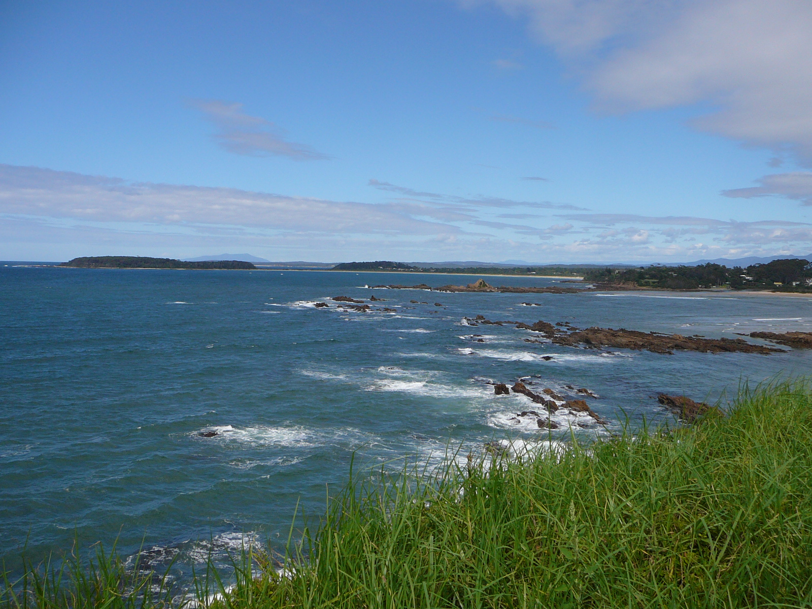
Most of the week was spent relaxing and swimming in the resort pool - a great life.  Cabarita Beach has a headland which juts out into the sea, separating the beaches.  The beach on the town side is popular with surfers and there were at least 50 in the water each day.  Most of them seemed to congregate just past the breakers and paddle around chatting.  There were only a few who seemed to do any surfing.  The views from this high point are spectacular along the coast and inland to the mountains.


The vegetation around the headland is coastal banksias and palm trees which have large segmented seed pods.


Thursday was a nice sunny day so we went back to Tumblegum to take some photos. Tumblegum is on the Tweed River and is about halfway between Cabarita Beach and Murwillumbah. It's quite a historic town and you can hire houseboats to holiday on the river. The Tavern was built in 1857 and there are several old buildings in the town, including a church which is for sale. We spent some time browsing in the Gallery which has many artworks by local artists. We were very taken by some of the furniture which was beautifully made and which would fit in with our existing furniture. A pity we don't have anywhere to put it - or maybe it was a good thing as we might have been tempted to make some purchases.  The Tweed River  and Tumbulgum are not immune to flood, although recent floods have not been as high as the 1954 flood level.

Tumblegum is also the birthplace of Faith Bandler (nee Mussing) A.M. who was a co-founder of the Aboriginal Australian Fellowship which was responsible for removing the legislation discriminating against aboriginals in 1967.  She has a long list of distinctions including an Order of Australia.  There's a park named after her and a memorial stone with a plaque.

Friday 9th March and we've said goodbye to Tamarind Sands and Cabarita Beach and we're heading south towards Sydney. We have driven about 550km today past macadamia nut, sugar cane and banana plantations. We're staying at Forster which is on Wallis Lake in the Myall Lakes region for a couple of days before we drive to Sydney on Sunday.