Tuesday, 28 October 2014

Art on the Salt Lake

About 60km from our last camp at Niagara Dam is the small town of Menzies.  We're about 130km north of Kalgoorlie-Boulder where we're off to tomorrow for a week.


Like many towns in the goldfields, Menzies was once a thriving town with a population over 10,000 and 13 pubs, 3 banks, a brewery, a post office with 26 employees, a school with 205 students, a public library and 4 churches!  By 1910 the population had dropped to 1,000 when the gold ran out.  These days there's only a few hundred (if that).  Some of the old buildings are still here and there's a great historic walk with steel cut-outs and interpretive panels.  There's still one pub with good food - we had lunch there yesterday.


About 50km out of Menzies, on the Sandstone road is the Lake Ballard salt lake.  The lakes here were once a vast river system which has dried up.  The average annual rainfall here is only about 250mm (11"), so any rain that falls evaporates very quickly.  The only time there's water in the lake is when the remnants of a cyclone comes through - not very often.


Our main purpose of coming out to Lake Ballard is to see Antony Gormley's "Inside Australia" sculpture installation.  The 51 sculptures are derived from laser scans of Menzies inhabitants.  The alien-like sculptures are placed on the salt lake and we walked around for an hour or so looking at the graceful forms.  Robert climbed up the pyramid hill for an overall look at the lake.


After morning tea we drove a bit further on to Snake Hill to another lookout.


This land has a spiritual quality and it's vastness really emphasises our insignificance in natures scheme.


Sunday, 26 October 2014

East to the Goldfields

We said farewell to the beautiful Chapman Valley and began to make our way east towards the Western Australian Goldfields.  We've decided that if we were to move to the west coast this is where we’d like to live.  It’s only drawback is that it’s 3,500km from the east coast!  Having lived on the east coast all our lives it’s strange to be heading east.


First stop Yalgoo, Home of the Emu Festival.  Yalgoo was almost the centre of the universe a few days before we arrived - on the day of the Northampton Airing of the Quilts Festival - when they hosted the Emu Festival.  One to remember for next time.  It’s only a very small town these days; in its gold rush heyday several thousand people lived in the area.  There’s plenty to see and we were kept busy visiting the sights of the area.


William Nottle discovered gold near here in 1894 and his lease, originally called Nottes Find, was known in the area as The Joker.  Jokers Tunnel is not on Joker’s lease and is all that remains of a gold lease, The Star of Bilberatha, which did not live up to expectations.  As we drove around the area we came across many ruins.  Some like this one are the result of a homestead that moved when the road was put through, others are all that remain of once vibrant gold rush towns.


The Yalgoo Museum is housed in the old Courthouse , Police Station and Lockup.  Well worth a visit to see some of the local judicial history.


The Convent Chapel of St Hyacinth was built by Dominican Sisters in 1919.  It’s another of the many masterpieces of Monseignor John Hawes.  The convent buildings are long gone, and the chapel was renovated a few years ago.


Our next stop after Yalgoo was the 123km drive further east to Mount Magnet on the Great Northern Highway which travels from Perth to Broome.  The Shire has a population of about 700 and there are several shops to stock up if necessary.  We’ve stayed here for a few days.  The local Tourist Drive took us through mining country.  The Harmony Gold Mine machinery is digging up plenty of dirt.  We drove to the Mount Warramboo Lookout to get views of the mining operations and town of Mount Magnet


After leaving the lookout we passed by the Mother and Child Grave.  Their identities are unknown and it is believed that they died in tin the typhoid epidemic of 1908.  In many cases like these people were buried where they died.


The Ampitheatre is one of several rock formations with the rocky breakaways surrounded by saltbush and mulga plants.  We are seeing plenty of seed heads of everlastings.  Most are white but sometimes we come across pink ones.


As we came closer to Mount Magnet on our round trip, we detoured to The Granites.  The escarpment is about 15m high and formed by the erosion of soft white granite from beneath a hard red iron capping.  There are many caves in the area.


The next day we packed our lunch for a drive to Walgan Rock and Cue.  First stop was the Meteorite Crater on Dalgaranga Station.  The crater is 25m in diameter and 5m deep, the result of a 100 tonne meteorite crashing into earth about 3,000 years ago.  The crater was discovered by Billy Steward, an aboriginal stockman, in 1921.  It is the smallest of the 18 authenticated Australian meteorite craters.  There are 180 authenticated craters worldwide.


We continued on to Walgun Rock, also known as Walgahna.  Rock art here has been dated as up to 9,000 years old.  There are many different styles and layers of paintings.  One of the most interesting is of a fully rigged sailing ship, complete with portholes.  This is intriguing because we are about 300km from the coast.


We ate our lunch here before proceeding on to the historic town of Cue.  


There are many interesting buildings including the old jail built from stone and the Masonic Lodge built from corrugated iron.


Back to Mount Magnet with its interesting buildings including an open air cinema.


Further east, our next stop is Sandstone.  No school, no police station, a pub with a general store, information centre and museum (open April-October), shire office, golf course and a caravan park.  The Bush Nurse comes every 2 weeks and the Flying Doctor has a monthly clinic.  Another tiny town with plenty to do for a few days.


The Heritage Trail incorporates both town based and out of town attractions.  The Contradiction Well was the town’s first water supply.  The well was 100m deep and was operated by a hand windlass and bucket.  It was mainly used for watering horses and livestock.


The Old State Battery was shifted to its current site out of Sandstone in 1925.  It was original sited at Paynes Find, about 100km south, from 1908.  In it’s productive life 135,809 tons of ore were treated by the battery, producing 115,787 ounces of bullion before its closure in 1982.


London Bridge is a natural bridge formed of weathered basalt.  It is estimated to be about 350 million years old.  It has been a popular picnic spot for over 100 years, just a pinprick in the geological history of the formation.


Our final stop on the trail was the Brewery.  All that’s left now is the stone cellar which has been cut into the rock, still lovely and cool in the 35+C heat.


Back in town, we stopped at the Gold and Wool Interpretive Park with it’s lovely gardens and interesting information panels.  Lovely gardens are a feature of this town in the desert.  Even in the harsh climate of the area there’s greenery and flowers.

Before our departure on Thursday morning we have to make a detour to buy some of Lady Di’s delicious meat pies - made on the spot while we wait.  We bought enough for a couple of meals, so have some in the freezer.  Next to Lady Di, William is selling fresh vegetables from his home market garden and fresh home baked bread.  It’s great to get fresh produce that hasn’t travelled hundreds of kilometres to get to us.

A brief stop at Leinster, a company town, for coffee and we’re heading south on the Goldfields Highway towards Kalgoorlie.  We won’t be there for a few days though.  We had thought that we’d spend some time at Leonora but decide to head into the bush to Niagara Dam, about 70km south.  


There are quite a few people camped here - no phone, TV or WiFi.  It’s rocky country with clear blue skies and mulga bush vegetation.


The dam has plenty of yabbies - a few less since we’ve been here.  This huge ant mound, over 1metre in diameter, is testament to a very old established ant colony undisturbed by echidnas and humans.


After a day of R&R we’ve decided to do a drive along one of the Leonora Loop roads through deserted mining towns like Niagara and Kookynie and past the Malcolm Dam with its waterbirds, to Leonora.


A few kms south of Leonora we turn off to Gwalia.  This once thriving town.population around 1,700, is now largely deserted with a population of only 15-20.  The Sons Of Gwalia gold mine has had a checkered past and is currently an operating open cut mine owned by St Barbara Mines.  The current pit is about 1km wide and 300m deep.


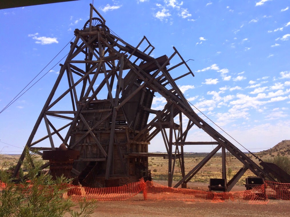
The Gwalia Museum was a real surprise packet.  It had been recommended to us and we’re please we spent the time visiting it.  The mine dates back to the 1890s when it was a pit mine.  The Sons of Gwalia Reef was discovered in 1896.  The mine manager was a new graduate from the United States, Herbert Hoover, who went on to become the 31st US President.  He designed and built the angled head frame in 1899.


The steam driven winder was the largest in the world when it was installed here in 1913.  The pit mine closed in the 1920s and new technology resulted in the open cut mine we see today.


A lot of the original buildings are still in evidence and house museum exhibits.  Many items were salvaged after the mine closed in 1963 and the miners and their families left to work in other mines.  The population went from about 1,500 to about 100 in a matter of days as people left with only what they could carry with them on the train, leaving their homes and mementos behind them.


Hoover House was built by Herbert Hoover at a cost of 600 pounds, when most houses cost only 100 pounds.  It has been renovated and some of the original furniture remains.  These days it's used as a B&B as well as a tourist attraction.  We had coffee on the shady verandah overlooking the gardens and mine.